
Search Mason Property Records
Deeds, assessments, tax bills, and parcel maps for Mason all come from Mason County. Start with the county assessor. Search by street name, owner, or full parcel number. The town and its rural edge share one countywide parcel scheme, so a post-office label will not tell you where the town limit runs. An older deed may cite the Waggener district instead. When that happens, ask the Assessor to connect the historic wording to the current parcel ID.
- Search the address through E-911 or use the Mason County IAS Street Name field.
- Copy the current district, map, parcel, suffix, owner, and legal description.
- Ask the County Clerk for deeds and plats using the modern ID and any old lot reference.
- Call the Tax Office for current balance or delinquency rather than infer it from a map.
- Ask the Mason municipal office about permits, zoning, street numbers, utilities, and town limits.
The county Mason County property search page walks through the exact fields this route uses. A full parcel number is the surest way to tell a town-center lot apart from a rural parcel carrying the same mailing city.
Mason Town and County Files
Mason County divides the work cleanly. The County Clerk records deeds and plats. The Assessor maintains parcels and valuations. The Tax Office handles bills and delinquency. The WV Property Viewer maps every county parcel, including those inside Mason town. Town Hall covers a separate lane: local ordinances, streets, utilities, permits, and zoning, where such files exist.
Mason publishes no online permit or zoning lookup. Ask the municipality directly which custodian holds the file you need. Give the property address, parcel ID, work type, and date range. The town does not replace the county recorder or assessor.
Mason County Property Data
County deed, assessor, tax, and GIS records cover Mason town and rural Mason parcels.
Mason Town Records
Ask the town custodian for permit, zoning, utility, street, and boundary files.
Mason, West Virginia
Waggener and Mason Parcel IDs
Historical Census material places Mason town within the old Waggener district. That context helps when reading an old deed or map, but it proves nothing about the assessor's current district number or parcel prefix. Pull the live Mason County result and copy the district, map, parcel, and suffix exactly as shown. The Census incorporated-place table lists Mason's 2020 town count next to the county's other incorporated places.
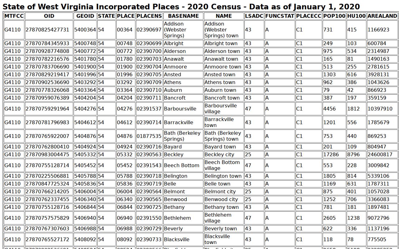
The population entry helps you pick the right Mason from a roster. For land, rely on the parcel ID and legal description.
An older instrument may carry a Waggener label or cite an unfamiliar map book. Ask the County Assessor how that reference maps to the active parcel. Keep the old and new identifiers side by side. The legal description forms the bridge between historic records and today's map. The County Clerk's recorded instrument completes that bridge.
Never convert a historical district name into a modern parcel prefix. The town publishes no current map range. Rural properties with Mason mailing addresses can sit outside the incorporated place. Start in Mason County. Copy the full identifier the system returns, and carry its legal description into any deed or plat request. That method keeps the Waggener-era clue and today's assessment key intact. It does so without treating them as the same thing.
Mason's Rural Address Edge
A Mason postal city can stretch across outlying county parcels. Mason publishes no official ZIP or PO-box crosswalk. There is no annexation map and no current town zoning map. So keep mailing address, physical address, town limit, tax district, and parcel boundary as separate facts. A shared road name never proves that two parcels both sit inside the municipality.
E-911 rejects rural routes and PO boxes. If an address match fails, search IAS by street name. You can also fall back on the parcel components. When incorporated status matters, compare the map's community-boundary layer against a town record.
Record the physical address, mailing address, postal city, tax district, and town limit as distinct fields in your notes. No official ZIP-to-town crosswalk exists. When a property is described only as Mason, verify the parcel's community-boundary context first. Then request the town's street or utility record if municipal service is the real question.
Mason's County Deed Trail
Mason town sits inside the county's deed series that local sources trace to 1804. That date marks the paper trail, not any web index. No public online grantor-grantee search reaches back that far. Ask the County Clerk for the right series. A terminal, paper index, book, or microfilm may cover your older lot or property description.
An old town-lot deed may describe the land in older terms. It may name the proprietor, the lot and block, and the adjoining owners. It may give acreage or a historic district reference. None of these is a modern IAS number. Copy the exact wording. Follow its citation to the prior deed. An estate or trustee may have conveyed the property. The county's fiduciary series may explain the transfer. That series is said to begin in 1840.
At each step, record the grantor, grantee, date, and instrument type. Add the book, page, and full land description. Then chase the next deed. Lot descriptions shift when land is divided, combined, or burdened by a right of way. Ask the Clerk about the cited book. It may be available by staff search, terminal, paper volume, or microfilm. Treat 1804 as a starting point for that request, not a promise of online coverage.
Mason Town Permit Requests
Mason publishes no official permit or zoning database. A direct request works best when it states the address, parcel ID, owner if known, type of work, and date range. Ask for building permits, certificates, zoning decisions, code actions, street-number changes, utility records, and demolition files if the town keeps them. If no file exists, ask staff to confirm that or point to another custodian.
For due diligence, a town request complements rather than replaces county deed, assessor, and tax records. Request the municipal boundary, street list, and any recorded annexation or plat-vacation material. The County Clerk holds the land instruments; the town explains its own ordinances and service records.
Mason Town Value Checks
The 2020 Census put Mason town at 866 residents. That headcount says nothing about prices. No official townwide revaluation percentage or trend exists in public materials. Compare a town-center lot, a developed home parcel, and rural acreage only after noting their different use and size.
For each parcel, record the assessment year. Record the land, building, and total appraisal, deeded and calculated acreage, last-sale fields, tax class, land use, and exemptions. Then inspect the deed for consideration and the legal description. The annual assessor process supports a solid tax value comparison. But it cannot prove any particular growth rate for the town.
Mason Town Lots and Plats
No official online list of Mason town subdivisions or named plats exists. The table points to record groups worth inspecting, not confirmed subdivision names. Use the Clerk's exact plat title and filing date. Apply a local label to a property only after that. A tax map can show how parcels sit together. But the filed plat controls the subdivision description.
| Neighborhood / Subdivision | Era | In the Records |
|---|---|---|
| Original town lots | Filing years not verified | Request lot/block and original proprietor from Clerk books. |
| Town-center streets | Names and dates require record check | Compare street address with legal description and plat. |
| Road, creek, or river parcels | Specific plats not located online | Use deeded acres, adjoining calls, and map references. |
| Rural homes mailed to Mason | Not necessarily inside town | Check parcel ID and community boundary. |
Start with a verified plat name, lot, or proprietor at the County Clerk. Then connect the result to today's parcel ID. The Mason County deed records page explains the county's deed-history limits. It also covers the Record Room fallback.
When a plat turns up, preserve its filed title, date, book and page. Keep the original lot and block label too. Save any notation vacating or replatting the area. Then compare that name against the current assessor legal description, deeded acreage, district, map, parcel, and suffix. A parcel-map display can make two lots look continuous. A street, creek, or old adjoining-owner call may still separate them. The filed document supplies the description to follow.
Mason's Municipal Boundary Check
Mason publishes no official annexation history or boundary ordinance. The municipal contact directory is a place to start, not a parcel map. Request the current limits, street list, street-acceptance records, and utility extensions from the town. Also request any boundary adjustment. Ask the County Clerk for recorded annexation, plat-vacation, or easement instruments.
The GIS community-boundary layer helps with orientation. But a town limit, a tax district, and a parcel line answer three different questions. An older deed may name a district or lot. Ask the Assessor how it connects to the current parcel. Do this before trusting a map prefix.
Limits of Mason Town Records
Mason town property records can show assessor attributes, recorded conveyances, mapped parcels, and town files the local office maintains. They cannot prove occupancy, an exact surveyed boundary, market price, or a complete title history. A Mason mailing address never proves the property sits inside town limits. Match the deed description, parcel ID, and municipal record to the specific question at hand.
Lawful use. Use Mason property records for parcel research, due diligence, house history, or civic questions. Do not use names, mailing addresses, or maps to stalk, threaten, harass, or harm anyone.